Tag Archives: Hebridean Way

Hebridean Way: Day 8 – Day off at Uig Sands

Distance cycled 0 miles / 0 km
Cumulative distance cycled 201.3 miles / 324.1 km
Islands visited (daily total) Lewis
Total islands visited 10+1 of 10
Average speed n/a mph / n/a kmph
Weather conditions Windy and rainy. Very rainy

Joining 2 days worth of cycling together gave us a fantastic semi-wild camping spot and day off to recover and explore an area of Lewis that’s a good 20 miles away from the official Hebridean Way route. We’d seen a large wood carving near the entrance to the Uig Sands and Ardroil Beach community campsite so we went back to learn a little more about it..

Large wood carving of the King piece from the Uig Chessmen chess set, and explanation board

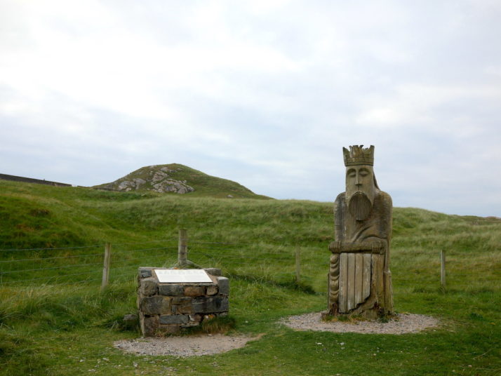
The very much enlarged wood carving of the king from the Uig Chessmen

This sculpture is based on one of the kings in the collection of walrus ivory chess pieces which were discovered nearby in a sand dune in 1831. According to the information board they’re believed to be of Norse origin, and 82 of the pieces are now in the British Museum, with 11 in the National Museum of Scotland.

Abhainn Dearg (Red River) distillery sign board and 2 whisky barrels

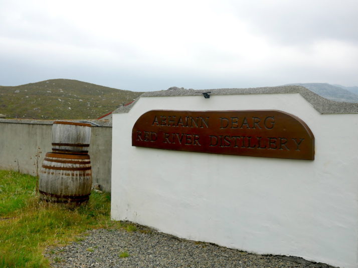
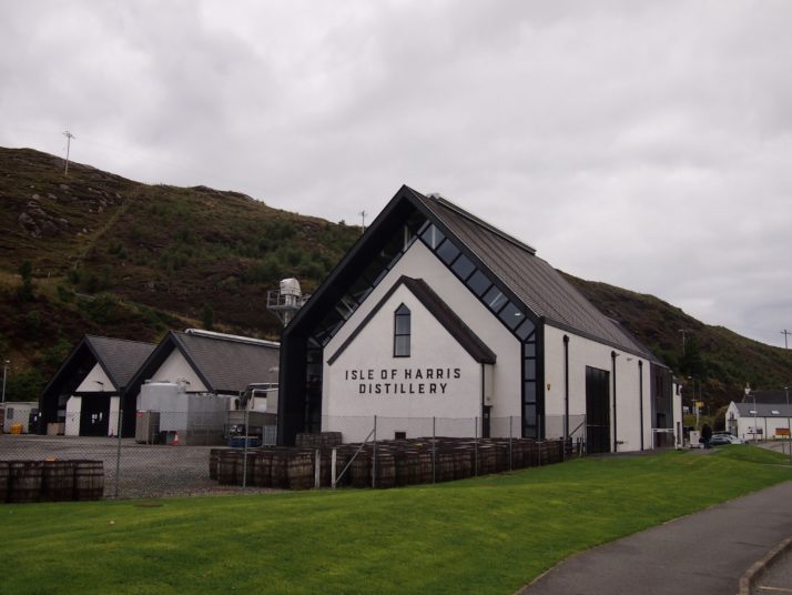
A few miles down the road is the first single-malt whisky distillery on the Outer Hebrides since 1829 – Abhainn Dearg or Red River. We understood they were open with limited spaces for tours, but like most of the businesses on the islands they’re closed on Sundays.

However, in their car park were 2 more Uig Chessmen carvings..

Andrew and Julie pulling silly faces in the style of the 2 Uig Chessmen carved statues

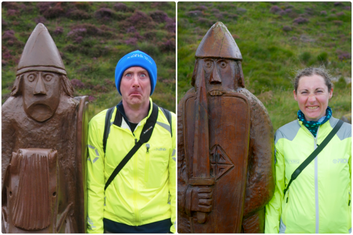
Two more carved Uig Chessmen were guarding the empty car park of the distillery – a knight on the left and a berserker on the right. Berserkers would bite their shields before battle to get themselves into a state of frenzy. Look out!

Another reason for the timing of our day off was the weather forecast we’d been keeping a keen eye on and sure enough, at this point the weather started turning for the worse. We headed back to camp via the sandy beach as the drizzle started and before the wind picked up. From the inside it felt like our little tent took a battering!

Hebridean Way: Day 7 – Harris, Lewis (Likisto to Uig Sands)

Distance cycled 65.7 miles / 105.8 km
Cumulative distance cycled 201.3 miles / 324.1 km
Islands visited (daily total) Harris, Lewis
Total islands visited 10+1 of 10
Average speed 11.2 mph / 18 kmph
Weather conditions Overcast

If anything, the midges were even worse in the morning. After eating our breakfast in the blackhouse, we struck camp as quickly as we could and struggled to get the panniers loaded on the bikes while keeping the clouds of midges off our faces. The only relief was to begin cycling, at which point they couldn’t keep up with us. Ha!

We retraced our route back through the rocky landscape to the main road and soon arrived in Tarbert, the capital of Harris. We restocked our food supplies making sure we had enough to get us through the weekend until the shops reopened. That left our panniers pretty full but passing the Isle of Harris gin distillery on the road out of town we found that we had space for a bottle of gin and some tonics!

Isle of Harris distillery, Tarbert

For the most part the Hebridean Way is quite flat with gentle ups and downs, we’d heard that the exception to this was just after Tarbert when there was A HILL. It was definitely the most uphill section but really not that bad, neither particularly steep nor long. From there it was rolling ups & downs between dramatic craggy hills until we stopped for an early lunch in a spot with a beautiful view over Loch Seaforth.

From there we were zipping down the other side of the hills at a rather alarming top speed of 37mph which brought us into Lewis, our final island. Confusingly its not actually a separate island to Harris though they are very distinct in landscape. Heading north and with a slight tailwind and pretty flat road the cycling felt really good. There’s a real lack of campsites in this part of Lewis and we’d thought to wild camp, but having arrived at our potential camping spot around 3pm and with knowledge of bad winds and rain forecast for tomorrow we decided to press on and do 2 days of cycling in 1.

View towards Harris mountains

As we crossed the island from the eastern coast to the west we had a constant view of the hills of Harris to our left. They looked like a painting of an imaginary mountain range.

Reaching the western coast we turned off the official Hebridean Way trail towards Uig. At about 45 miles into the ride, I was still feeling pretty good though Andrew was starting to tire. The last 20 miles felt never-ending though the scenery made up for the tired legs. Eventually we arrived at the beautiful campsite in the dunes at Ardroil beach though as we pitched the tent the midges were annoying again. Instead of setting up the beds we went for a walk on the huge beach accompanied by a tailless dog who kept bringing us bits of seaweed stalk and looking at us expectantly.

Cooking dinner on Uig Sands

We decided to take everything out on the sands and make dinner there. It ended up being one of our favourite memories of the trip, in our new camping chairs, eating dinner and drinking Harris gin and tonics as the light slowly faded.

An epic day, over 65 miles which would be a long day for us even without the extra weight of the bags.

Hebridean Way: Day 6 – Harris (Leverburgh to Likisto)

Distance cycled 18.5 miles / 29.8 km
Cumulative distance cycled 135.6 miles / 218.3 km
Islands visited (daily total) Harris
Total islands visited 9+1 of 10
Average speed 10 mph / 16.1 kmph
Weather conditions Overcast and very still (perfect if you’re a midge)

After the long, tiring but extremely enjoyable previous day hiking around Hirta, and after many a discussion with our wonderful bed and breakfast hosts about locations of suitable wild camping spots the other side to Tarbet (which they lamented the lack of given the unsuitable moorland landscape), we decided to stop a little short and set off for a campsite just before it on the ‘Golden Road’.

The western coast of Harris, like the western coasts of the isles so far, is a string of white sandy beaches and gorgeous turquoise waters, each one as breathtaking as the last. We were compelled to stop at every one to pause, take in the view, and take a photo!

Scarista Mhor

Horgabost

Seilebost. I think it’s a requirement to pull into the lay-by and appreciate this view. While we were here a guy hopped out of a camper van and said “Devon & Cornwall aren’t a patch on this”

After crossing to the east coast of Harris we turned south away from Tarbet and onto a lovely twisty single-carriageway called the Golden Road – very nice on a bicycle!

Julie on the Golden Road

Soon we arrived at Likisto and our home for the evening, but the welcoming party of midges soon found us and with no breeze whatsoever at our pitch they were about as thick as we’ve seen them. We just managed to put the tent up then retreated into the converted blackhouse where we found not only a small kitchen, bathroom and shower, but a huge lounge and dining table! Best of all it was a midge free zone!

Inside a converted blackhouse

Inside the very homely converted blackhouse. We spent the remainder of the afternoon drinking tea and writing up our diaries, then set up the stove in one of the fireplaces to avoid the midges!

Julie had explored the campsite and found another pitch named ‘Otter Watch’ right by the loch side and with just enough breeze to keep the midges away the spot proved true to its name – we spotted one, then two, then three sea otters – shame we’d left both the cameras and the binoculars in the tent!

Hebridean Way: Day 4 – North Uist, Berneray, Harris

Distance cycled 26.9 miles / 43.3 km
Cumulative distance cycled 117.1 miles / 188.5 km
Islands visited (daily total) North Uist, Berneray, Harris
Total islands visited 9 of 10
Average speed 10 mph / 16.1 kmph
Weather conditions Blue skies & sunshine, cool breeze

We woke to a beautifully clear, crisp and sunny morning with a fairly short ride ahead of us to make the second and final inter-island connecting ferry. This north western area of North Uist is how I had imagined the Outer Hebrides: Remote. Sparse.

Small stone folly or tower on an island in the middle of a loch

Scolpaig Tower, a small folly built on an island in a loch. A suitable metaphor for the sparseness of this part of the Outer Hebrides and is why I think North Uist is my favourite of the trip

3 horned sheep grazing with rolling hills behind them

Sea Eagle souring high in a clear blue sky

A Sea Eagle! It was circling overhead long enough to get the zoom lens on the camera and this is the best photo – it was about a mile away at this point

The causeway onto Berneray seemed like it was always going to be over the next rise or just around the next corner, instead it teased us, just out of reach with more sparse rolling countryside until eventually we were leaving North Uist. After a very decadent packed lunch of local smoked salmon and seaweed water biscuits, we took the ferry hoping we’d see sea otters. Sadly it wasn’t to be, and as the terminal is pretty much at the causeway we didn’t see much of Berneray either.

We dropped our bags at the bed and breakfast in Leverburgh – our home for the next couple of nights – and with lightened bikes headed south east to Rodel to visit St Clement’s church which has some very detailed carvings inside and out.

St Clements Church, a small church

St Clements Church at Rodel. We got to it and the signs said follow the road to the right (even though the parking was straight in front of us) and we ended up cycling all the way around it where we serendipitously passed The Girnal – an old storehouse in Rodel’s tiny fishing harbour

We ended the day with a lovely meal in The Anchorage.

Hebridean Way: Day 3 – Grimsay, North Uist

Distance cycled 15.5 miles / 25 km
Cumulative distance cycled 90.2 miles / 145.2 km
Islands visited (daily total) Grimsay, North Uist
Total islands visited 7 of 10
Average speed 10.2 mph / 16.4 kmph
Weather conditions Cloudy with sunny spells, no wind

After a rude awakening just before 5am when the truck started up his engines we dozed for a while. The wind had dropped overnight and a glance through the mesh windows of the tent showed an alarming number of midges gathering in our porches… We packed as much as we could inside but eventually we had to run the gauntlet and unzip the tent. Fortunately, it wasn’t too bad once we were outside and there was enough breeze that we felt safe to boil the kettle and have a spot of breakfast without being eaten alive.

Cycling the gentle roads on North Uist

Cycling the gentle roads on North Uist

The road barely touches the corner of Grimsay and we were soon across the next causeway onto North Uist, where we found a lot more water than the earlier islands with the gently rolling road across the moorland passing many small lochs. Entering the village of Carinish, I saw an information board in front of a small church. Tourist information boards had been few and far between so far, so I pulled across to see what it said. It referred to the ruins of Trinity Temple (Teampull in gaelic) which was along the track behind the chapel and across a field of grazing sheep. A medieval ecclesiastical college and monastery, we had a quick look around but it was built above swampy ground and was swarming with midges.

The remains of Trinity Temple in Carinish

The remains of Trinity Temple in Carinish

We didn’t want to take the ferry to Harris until tomorrow which meant we either had a short day and a stay at the campsite at Balranald in the island’s north-west corner or carry on a bit further and look for another wild camping spot. Tired from yesterday’s ride and fancying a shower we opted for the former. An early finish to the day’s cycling meant that we had time to wander the circular path around the neighbouring RSPB reserve. Mainly consisting of machair, a wildflower filled coastal grassy plain, it is an important habitat for ground nesting wading birds as well as the endangered corncrake. The charity also works with local crofters to preserve traditional farming techniques which protect the nests.

 The path through the machair at Balranald Nature reserve

The path through the machair at Balranald Nature reserve

On the way to the campsite we had stopped in the very tempting factory shop of the Hebridean Smokehouse so our dinner of pasta pesto was made much more luxurious with a side of smoked scallops, afterwards we retired to the tent to sample a couple of miniatures of the local Downpour gin.