Author Archives: Julie

Hebridean Way Round Up

What photo takes you right back to the Hebridean Way?

Vatersay beach

The spectacular beaches made us get our cameras out every time, no matter the weather the sea seemed to glow turquoise and they were usually more or less deserted too. This is Vatersay on our first day

Summarise the Hebridean Way in three words.

  • Remote – not only are the islands themselves remote from the mainland but cycling there we often felt ourselves to be remote from the conveniences that we’re used to – there often isn’t a shop, cafe, restaurant, campsite or public toilet for tens of miles and we made sure to always have some food supplies in reserve, just in case
  • Rolling – the Hebridean Way isn’t a physically challenging route and we often found ourselves nicely rolling along up and down on the undulating roads
  • Resilient – from the neolithic standing stones dotted around the islands, to the remains of the village at St Kilda, and the museum in Stornoway, imagining how people have lived here over the centuries and dealt with the harsh conditions was a theme of our visit

You really know you’re in the Outer Hebrides when…

…all of the caution animal signs have googly eyes! We have no idea who travelled the islands adding these but they were there from the causeway at Eriskay all the way to Stornoway. Any humans in similar signs (riding the horse, pedestrians) were always blind.

What one item should you definitely pack when going to the Outer Hebrides?

Midge headnet and insect repellent. To be fair most of the time the midges weren’t too bad but when they did come out they were very annoying! We picked up headnets in Tarbert and they made the rest of our stay much more comfortable.

Hebridean Way: Day 12 – Lewis (Stornoway – castle grounds and Museum Nan Eilean)

Distance cycled 0 miles / 0 km
Cumulative distance cycled 319.2 miles / 513.9 km
Islands visited (daily total) Lewis
Total islands visited 10+1 of 10
Average speed n/a mph / n/a kmph
Weather conditions Heavy showers

Stornoway is the capital of Lewis and by far the largest town in the Outer Hebrides but by mainland standards it’s small with a population of just 5,000. Nevertheless, full size supermarkets, other shops and a choice of cafes, restaurants and pubs made it feel like a bustling metropolis to us after the last two weeks!

The weather was windy and drizzly when we woke with more rain forecast for later so we decided to go for a wander with the aim of ducking into the museum and/or a cafe if it got too bad. First stop was the war memorial at the top of the hill. It’s an impressive structure, built by subscription after WWI and added to after WWII, with views over the town and beyond.

Stornoway war memorial

From there we headed down the hill and into the castle grounds. Lews Castle is a 19th century stately home which now houses an expensive hotel as well as a museum and archive. The extensive grounds function as a huge public park and were basically deserted on a wet Thursday morning in September. We wandered some of the mountain bike trails through the dripping trees and could have been miles from anywhere. Eventually the path brought us down to the seafront which we followed to the Woodlands Cafe. By now it was starting to rain quite heavily so we sheltered under the eaves of the cafe until a table was available and after our meal made a dash to the museum which is located in an extension behind the castle.

Lews Castle Grounds on a damp September day

Lews Castle Grounds on a damp September day

Museum Nan Eilean (Museum of the Islands) as its name suggests tells the story of life on the islands. Over 50% of islanders speak gaelic as their first language and the museum recognises this with bilingual exhibits. It begins with videos of islanders speaking about their lives and continues with exhibits of different aspects from nature to religion to fishing and the arts. It’s compact but very well done and we thoroughly enjoyed learning more about some of the things we’d seen during our holiday.

Lews Castle and exhibits from Museum Nan Eilean

Clockwise from top: Lews Castle; a wedding dress made from very fine Harris Tweed; exhibit of music and religion in Museum Nan Eilean; we were excited to see some examples of the actual Uig chessmen

Stornoway and part of the harbour from the castle grounds

Stornoway and part of the harbour from the castle grounds

From the castle we walked down into the town. Our final stop was a beautiful and moving piece of art in Stornoway harbour commemorating the Iolaire disaster. HMY Iolaire was a Royal Navy yacht returning men to the islands after WWI. Tragically it foundered on rocks within sight of the shore and families waiting to welcome home their loved ones instead watched as 201 of the 280 on board drowned. The memorial consists of 280 wooden posts in the sand making the exact shape of the yacht, with 79 painted white to signify the survivors. It disappears and reappears with the tide, and is lit at night which unfortunately we didn’t see.

Iolaire memorial

Iolaire memorial

Hebridean Way: Day 11 – Lewis (Shawbost to Stornoway)

Distance cycled 29.2 miles / 47 km
Cumulative distance cycled 319.2 miles / 513.9 km
Islands visited (daily total) Lewis
Total islands visited 10+1 of 10
Average speed 11.6 mph / 18.7 kmph
Weather conditions Showers, very still, lots of midges

We knew that the ride to Stornoway wasn’t too long and as the weather didn’t look too bad we decided to pop into some of the nearby attractions that we’d skipped due to lack of time on the previous 2 days. First up was the Norse mill & kiln just outside Shawbost. It’s a short walk over a hill from the roadside car park, but by this point in the trip we were fairly blasé about leaving our bikes and all our stuff and didn’t even lock the back wheels. Crime on the islands is low and several locals told us that they never lock their front doors and that keys are left in the ignition of parked cars! The mill and kiln are a reconstructed site and we spent a while figuring out how the mill worked before we found the information leaflet explaining it inside.

Norse mill and kiln

Norse mill and kiln

Just a few miles down the road is the Arnol blackhouse, another reconstructed site but this time a proper museum. Sadly not open on the day we visited so we read the information board outside and wandered through the unreconstructed blackhouse ruins opposite. Blackhouses were the traditional form of dwelling for hundreds of years in the Hebrides and humans and animals shared the space. They didn’t have chimneys, this made the home easier to keep warm, the smoke killed bugs and the smoky thatch was a good fertiliser for the fields.

Arnol blackhouse

Arnol blackhouse (clockwise from top-left): the museum blackhouse; cut peats for the fire; unreconstructed blackhouse room; and entrance

Having enjoyed both of those sites more than we’d expected we decided to carry on past the turning for Stornoway to investigate a sign that we’d seen to another stone circle during our return from the Butt of Lewis. The weather was starting to come in and by the time we reached the Steinacleit circle parking area visibility was poor, it was raining lightly, midges were about and we were feeling a bit sorry for ourselves.

Steinacleit stone circle

The “circle” itself was disappointing after what we’d seen around Callanish, no excavations have been done and the best theory for the stones is that they are the remains of a prehistoric farm

The weather improved as we rode over the moor to Stornoway, and it was totally still so that the small lochs we passed looked like mirrors in the heather. It was beautiful but there’s not much photographic evidence of this part of the ride as the midges descended within seconds of pulling over, this also meant that we didn’t want to stop for lunch so we were starving hungry by the time we arrived at the campsite at the edge of town. Again the weather forecast for the following day looked poor and so we upgraded from the camping field to a couple of beds in the bunkhouse. Because of covid, rooms were reserved for household bubbles so we had a 4-bed room to ourselves as well as access to a shared kitchen and lounge – relative luxury for our last couple of nights in the Hebrides!

Dinner at Harbour Kitchen

We finished the day with a delicious dinner at Harbour Kitchen

Hebridean Way: Day 9 – Lewis (Uig Sands to Shawbost)

Distance cycled 37.9 miles / 61 km
Cumulative distance cycled 239.2 miles / 385.1 km
Islands visited (daily total) Lewis
Total islands visited 10+1 of 10
Average speed 10.7 mph / 17.2 kmph
Weather conditions Overcast with mizzly rain showers

When we were packing, we’d debated whether we should pack our swimwear and in the end decided yes – I’d had visions of lounging in the sun on the white sand beaches. As it turned out, it was a bit chilly for sunbathing but Andrew was adamant that he wanted a swim in the sea and as we were camped right next to the beach, today seemed the best opportunity. I wasn’t brave enough for full immersion and went for a paddle instead though actually the water was a lot warmer than I’d expected and maybe I would have been OK.

Andrew on Uig Sands after a swim in the sea

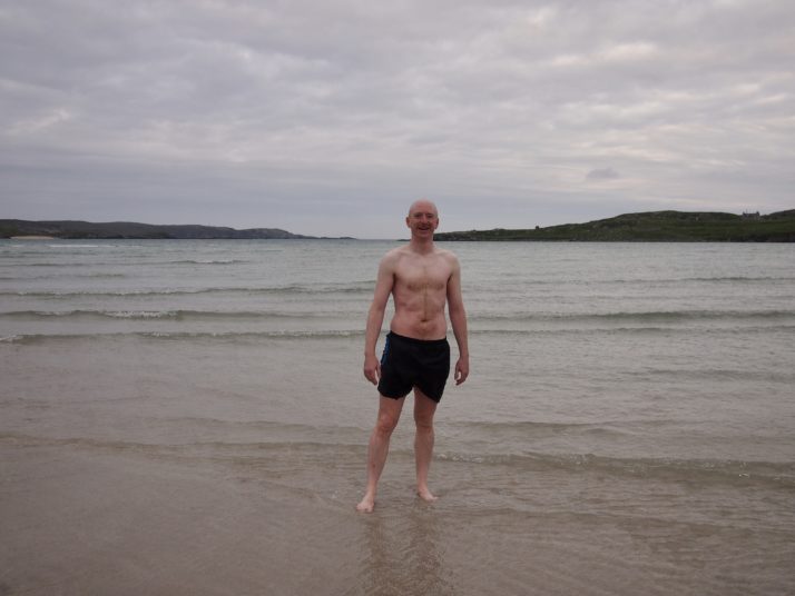
Andrew refreshed from his early morning dip in the sea

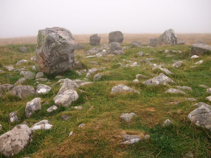
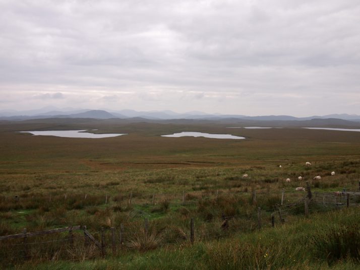
We set off cycling back towards the Hebridean Way route. For the first 10 miles we had a headwind but eventually the road turned and the going was easier. First stop of the day was at Callanish IV, a small stone circle which we’d seen from the road as we passed by 2 days before. I always find ancient sites like this magical, it blows my mind to think about how long they’ve been there and the people who constructed them.

Cycling on the road near Loch Roag Beag

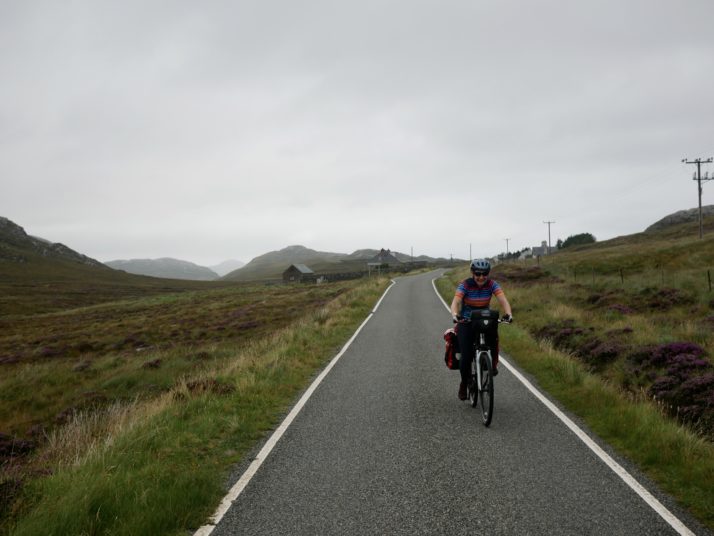
Julie battling the headwind on the road near Loch Roag Beag

Callanish IV stone circle

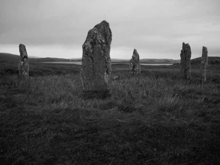
Callanish IV: there are more than 15 other sites with stone circles or standing stones in the area surrounding the Callanish Standing Stones

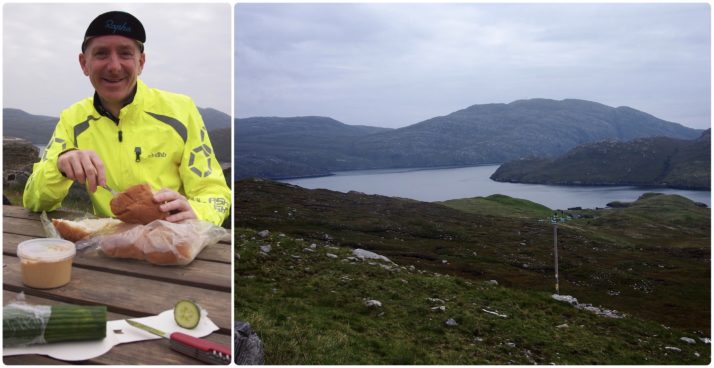
From there it was only a few miles to the famous stone circle at Callanish known simply as the Callanish Standing Stones. The weather wasn’t great with intermittent drizzly rain so I’d hoped we might be able to get lunch at the cafe. Unfortunately it’s closed on Mondays so we sheltered under the canopy over their outdoor tables and ate the bread and pate that we’d bought earlier.

Callanish Standing Stones

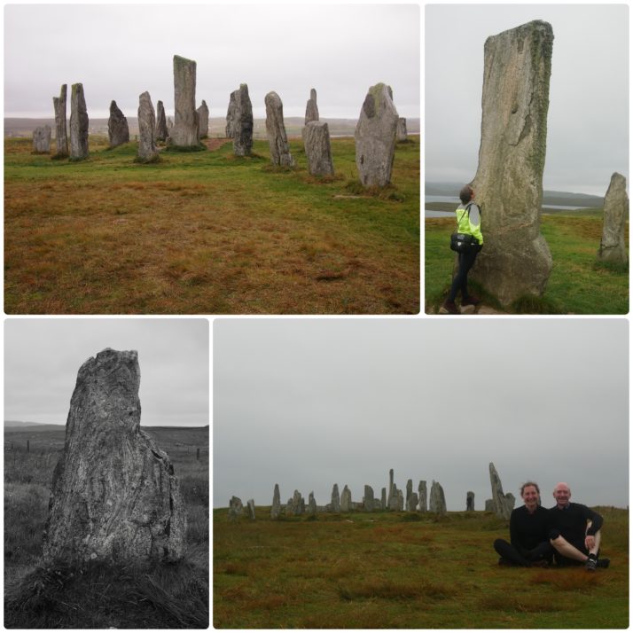
Callanish Standing Stones (clockwise from top left): the stone circle; Julie with the central monolith; us with the Stones; many of the stones had wonderful patterns in them

The Stones themselves form a cross shaped pattern around a central stone circle and were erected 5,000 years ago which makes them older than Stonehenge. Unlike at the more famous stone circle you can walk right up to them, and they’re free to visit too. We spent quite a while wandering around, taking photos from different angles and admiring the patterns in the stones and the height of the central monolith (4.75m).

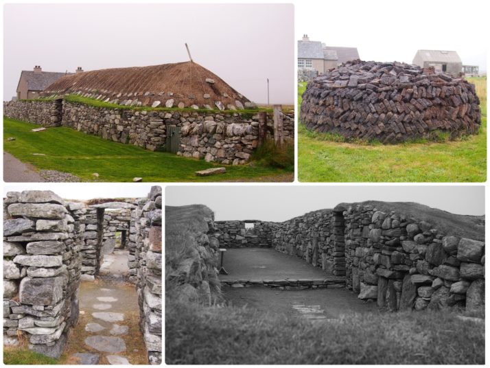
After a quick diversion when we noticed a roadside stall advertising fudge we stopped in at Dun Carloway, the remains of a 2,000 year old broch, a kind of double walled roundhouse.

Dun Carloway broch

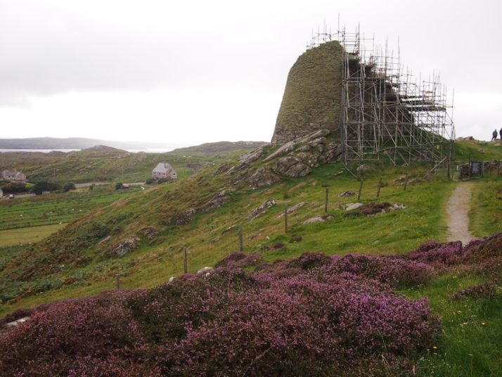
Unfortunately at the moment the broch is shrouded in scaffolding awaiting work to reseat loose stones

The poor weather had made for a tiring day and we were on the look out for somewhere to eat dinner so that we wouldn’t have to cook for ourselves. After the false promise of a knife & fork symbol on our route map we arrived in Shawbost. I was in favour of giving up and just checking into the campsite but Andrew had found the pin for a cafe on the online map so we detoured up a side road. We almost didn’t find Mollan’s Rainbow Shed and even when we did it didn’t look promising for dinner unless we wanted cake, but Andrew asked the owner, Julie, if she had anything more substantial. “Oh yes, there are homemade curries and pilau rice in the freezer, I can warm them up for you if you like”. Finished off with her chocolate “peat-bog” pudding, and with interesting conversation thrown in as well it was a perfect end to the day.

Hebridean Way: Day 7 – Harris, Lewis (Likisto to Uig Sands)

Distance cycled 65.7 miles / 105.8 km
Cumulative distance cycled 201.3 miles / 324.1 km
Islands visited (daily total) Harris, Lewis
Total islands visited 10+1 of 10
Average speed 11.2 mph / 18 kmph
Weather conditions Overcast

If anything, the midges were even worse in the morning. After eating our breakfast in the blackhouse, we struck camp as quickly as we could and struggled to get the panniers loaded on the bikes while keeping the clouds of midges off our faces. The only relief was to begin cycling, at which point they couldn’t keep up with us. Ha!

We retraced our route back through the rocky landscape to the main road and soon arrived in Tarbert, the capital of Harris. We restocked our food supplies making sure we had enough to get us through the weekend until the shops reopened. That left our panniers pretty full but passing the Isle of Harris gin distillery on the road out of town we found that we had space for a bottle of gin and some tonics!

Isle of Harris distillery, Tarbert

For the most part the Hebridean Way is quite flat with gentle ups and downs, we’d heard that the exception to this was just after Tarbert when there was A HILL. It was definitely the most uphill section but really not that bad, neither particularly steep nor long. From there it was rolling ups & downs between dramatic craggy hills until we stopped for an early lunch in a spot with a beautiful view over Loch Seaforth.

From there we were zipping down the other side of the hills at a rather alarming top speed of 37mph which brought us into Lewis, our final island. Confusingly its not actually a separate island to Harris though they are very distinct in landscape. Heading north and with a slight tailwind and pretty flat road the cycling felt really good. There’s a real lack of campsites in this part of Lewis and we’d thought to wild camp, but having arrived at our potential camping spot around 3pm and with knowledge of bad winds and rain forecast for tomorrow we decided to press on and do 2 days of cycling in 1.

View towards Harris mountains

As we crossed the island from the eastern coast to the west we had a constant view of the hills of Harris to our left. They looked like a painting of an imaginary mountain range.

Reaching the western coast we turned off the official Hebridean Way trail towards Uig. At about 45 miles into the ride, I was still feeling pretty good though Andrew was starting to tire. The last 20 miles felt never-ending though the scenery made up for the tired legs. Eventually we arrived at the beautiful campsite in the dunes at Ardroil beach though as we pitched the tent the midges were annoying again. Instead of setting up the beds we went for a walk on the huge beach accompanied by a tailless dog who kept bringing us bits of seaweed stalk and looking at us expectantly.

Cooking dinner on Uig Sands

We decided to take everything out on the sands and make dinner there. It ended up being one of our favourite memories of the trip, in our new camping chairs, eating dinner and drinking Harris gin and tonics as the light slowly faded.

An epic day, over 65 miles which would be a long day for us even without the extra weight of the bags.