Tag Archives: city walls

Sighnaghi and Davit Gareja, Georgia

After our day trip to Mtskheta, we ventured a little further afield to the south eastern region of Kakheti which, as well as the following sites, is also famed for its wine. Enroute to our destination of Sighnaghi and straddling the border with Azerbaijan is the 6th century cave monastery of Davit Gareja. Using public transport to get out this way would have doubled the time we needed, so we took the easy option and hired a guide-taxi through our Tbilisi guesthouse.

Davit Gareja

Davit Gareja, Georgia

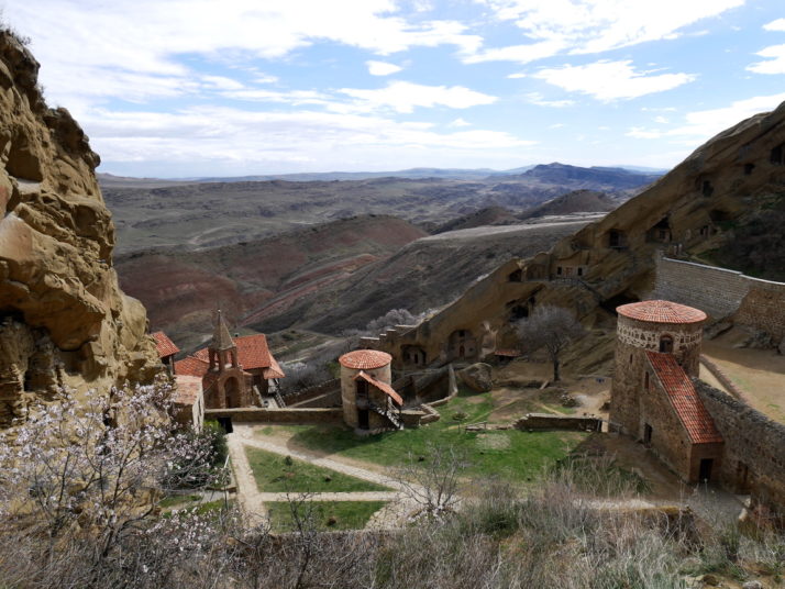
Looking down into Lavra monastery on the Georgian side of the Davit Gareja complex. The surrounding stripy red hills reminded us of the colourful landscape of Tsagaan Suvraga in Mongolia

After a long 2 hour drive through increasingly bleak and sparsely populated land we arrived at the remote monastery of Davit Gareja, a relative oasis compared to the dry and treeless surroundings. Our guide Giorgi explained that as well as carving out their single-cell shelters, the monks used diagonal channels in the rock faces to collect the little rainwater the area gets.

Davit's Cave, Davit Gareja

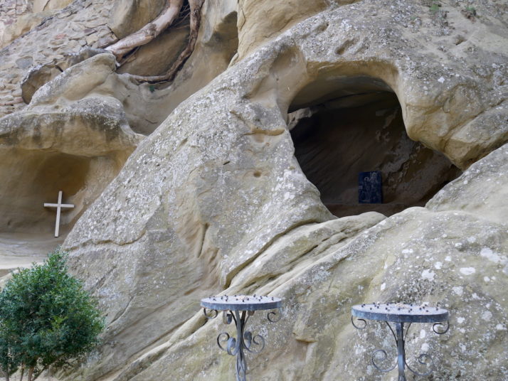
Davit’s cave, most likely dug by himself ~1,500 years ago

We were surprised to find much of this part of the complex is in use; the larger caves looked inhabited, some areas were cordoned off requesting visitors to kindly respect monk’s privacy, and there were about a half-dozen monks saying prayers in the small chapel which made it feel almost bustling.

From the upper courtyard we took an energetic trail up through the monastery, past a few more basic caves and a couple of armed Georgian border guards to the top of the ridge before dropping a little way down the other side. I wasn’t entirely sure why we’d left the monastery and were following a path that is essentially the border with Azerbaijan until we’d gone about 100 meters..

Davit Gareja, Georgia

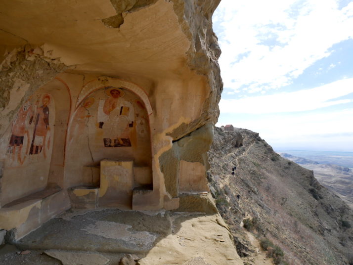
Oh! That’s why! Obviously we knew it was a cave monastery but I had no idea how big it had been and that a lot of the caves had been covered in frescoes painted in the 10th to 13th centuries

Frescoes, frescoes everywhere!

Davit Gareja collage

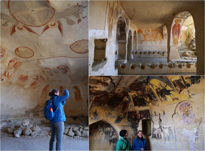
Exploring the frescoes, including the dinner hall (top right) with a depiction of the last supper

We spent a good hour or so working our way along the remains of the frescoed caves, many of which were just open to the elements. It was amazing how well they’d held up to the weather given a lot of walls had fallen away, but it was bittersweet that some Soviet visitors had scratched their names into the plaster.

Davit Gareja, Georgia - Close up of the Soviet graffiti

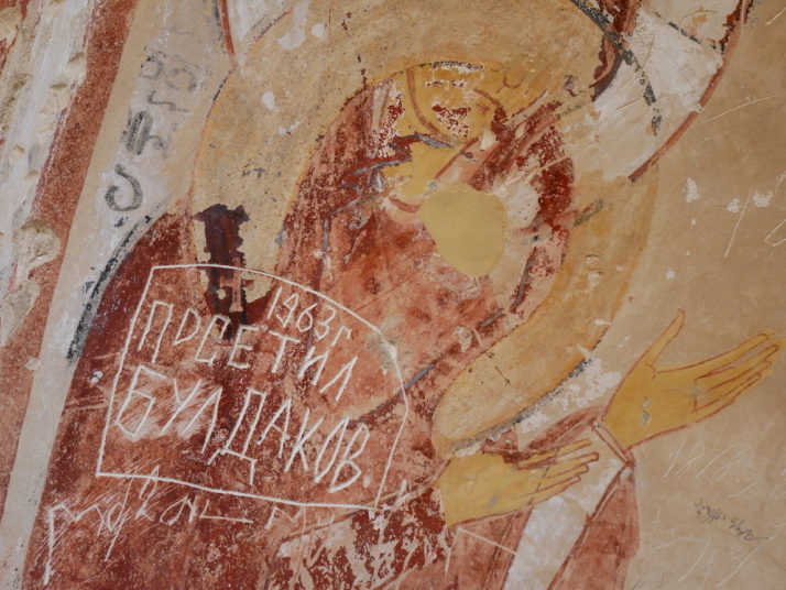
Soviet era graffiti – it’s a shame but it’s also a reminder of that period in the monastery’s history
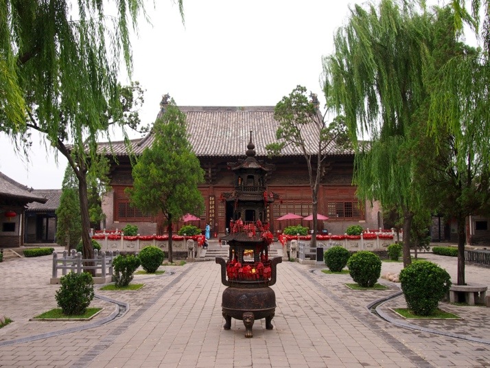
Bodbe Convent

Bodbe Convent, Georgia

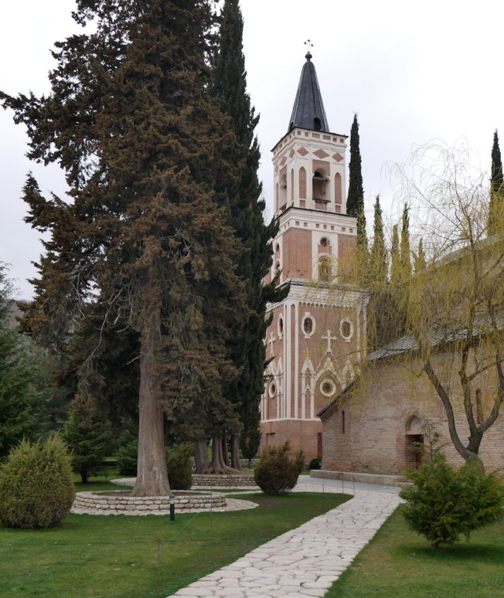
The church (right) and bell tower of Bodbe Convent. The grave of St. Nino is inside

From Davit Gareja we drove another 2 hours to reach the outskirts of Sighnaghi. We’d planned to visit Bodbe Convent the following day, but as Giorgi and our fellow tourist Daniel were due to head back to Tbilisi the same day it made sense to include this small but important site in the itinerary. Set amongst tall cypress trees and lush, immaculately kept grounds, the peaceful Bodbe Convent is the final resting place of St. Nino, who converted the King and ultimately Georgia to Christianity.

New church, Bodbe Convent, Georgia

They’d nearly finished a new cathedral-sized church in the grounds of the convent. It looks almost complete from the outside with a lovely mix of texture and materials but it was still a building site inside

Sighnaghi

Sighnaghi, Georgia
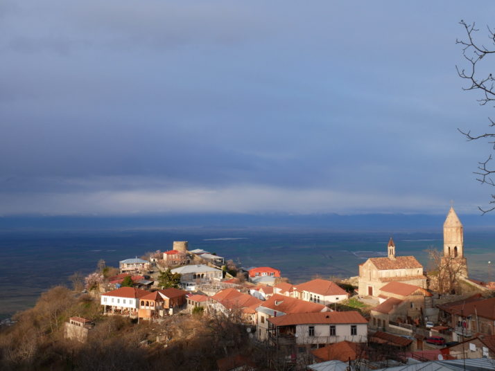
Our base for a couple of nights was Signhaghi, a laid-back, quiet, picturesque hill-top town ringed by a turret studded wall. Given that we’d already done our day’s sightseeing activity before we’d arrived, we took a leisurely wander around the town’s walls which afford spectacular views of the wine growing Alazani valley and Caucasus mountains beyond (when there aren’t clouds in the way!).

Sighnaghi walls collage

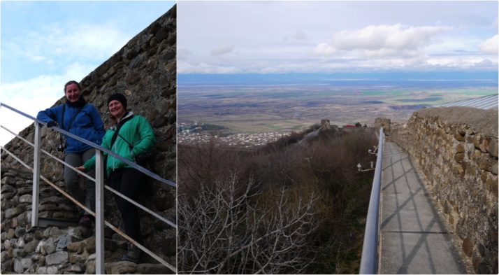
One of the few staircases onto the walls around Sighnaghi that aren’t in the round turrets

Sighnaghi Museum, Georgia

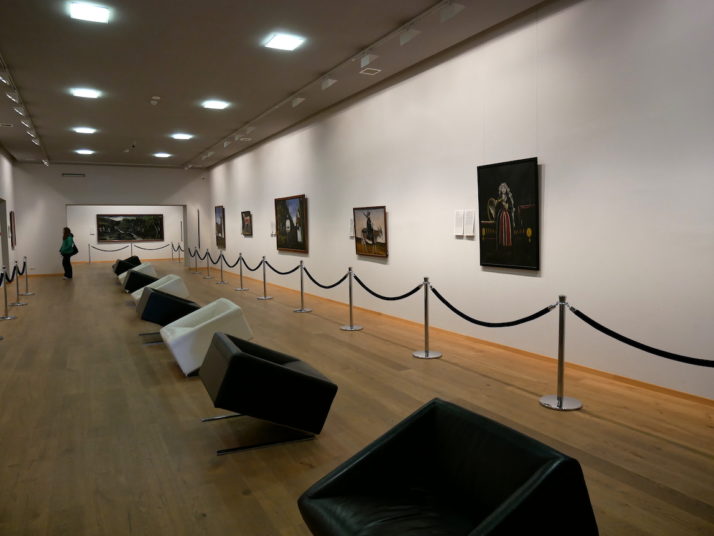
Just off the main town square is the small but excellent Signhaghi Museum which finishes with a collection of works by the famous pauper painter Pirosmani who was born in Kakheti

After a lazy day of wandering around in the morning and catching up with photos and diary writing in the afternoon we spent the evening indulging in great food and very good, very local wine!

Pheasant's Tears, Sighnaghi, Georgia

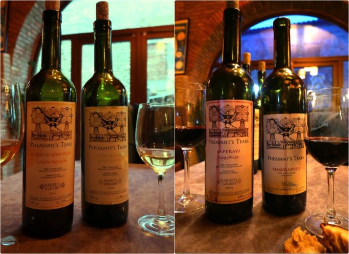
We opted for the wine tasting menu to accompany the food at the renowned Pheasant’s Tears which consisted of 6 wines from vineyards across Georgia

Pheasant's Tears, Sighnaghi, Georgia

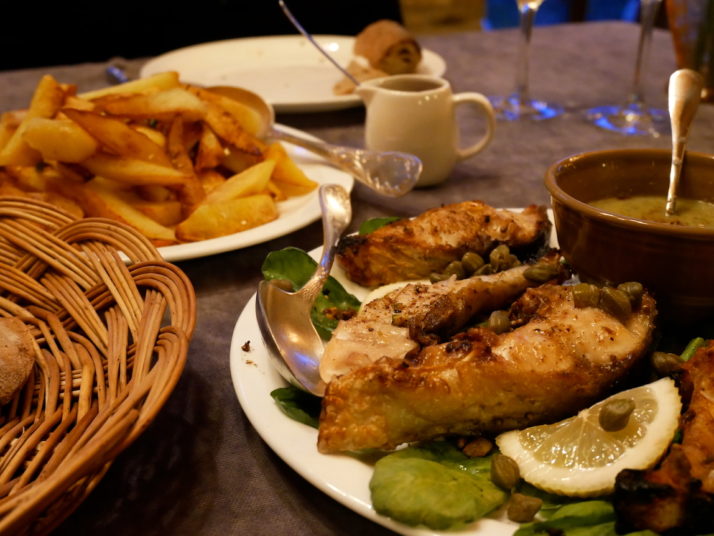
The food we had in Sighnaghi deserves a mention too – we unconsciously ordered fish and chips with our wine tasting – how does the saying go? you can take the British out of Britain..

The Kakheti region makes up about 60% of Georgia’s vineyards and has been a wine producing area for over 8,000 years. To this day the Georgians take enormous pride in their traditional method of natural fermentation in large clay pots called qvevri sunken into the ground. They also use the whole grape – skin and pips – which turns their white wines a rich sunset amber colour, though they’re still light and refreshing. Delicious!

Appian Way, Rome

You’ve heard the phrase “All roads lead to Rome” and indeed in the days of the Roman Empire the notoriously straight Roman roads all led to (or fanned out from depending on your perspective) the Miliarium Aureum, or golden milestone, in the centre of the city, and all distances in the Empire were measured relative to that point. One of these Roman roads, the Appian Way, is relatively well preserved as the area around it has been declared a national park. We decided to explore it one sunny Sunday.

Porta San Sebastiano, RomePorta San Sebastiano in Rome’s ancient city walls is now home to the Museum of the Walls

We started at the point where the Appian Way crosses the Aurelian walls, the Porta San Sebastiano, which has now been turned into a small museum telling the history of Rome’s city walls. The Aurelian walls were the second set of encircling walls to be built around Rome, they were constructed in the 3rd century AD to protect the expanding city and extended for 19km (12 miles). We’ve seen quite a lot of sections in various places around the modern city so it was interesting to find out how they were used for defence and how the gates changed over time, for example, to accommodate new war machinery.

First milestone on the Appian WayJust beyond Porta San Sebastiano is milestone one of the Appian Way

Construction of the first part of the Appian Way began in 312BC and eventually its course ran as far as Brindisi in south-eastern Italy, the heel of the boot. Its name comes from the man who ordered its construction, Appius Claudius Caecus, a Roman censor and its initial purpose was to enable fast supply to the Roman army in a war with the Samnites in south-central Italy – an aim which was successful as the Romans won the war.

Appian WayThe first stretch of the Appian Way outside the Aurelian walls

We’d chosen to visit on a Sunday as we’d read that all but local traffic was banned on that day. If that’s the case, we’re glad we weren’t there on a normal day as a steady stream of cars seemed to be flying past, rattling noisily over the paved lane. The first monument that we had hoped to visit was the Church of San Sebastiano but, as we arrived, mass was just beginning and we didn’t really want to join in so we sat in the nearby car park to eat our lunch.

A little further along we came to the Maxentius complex. A large area containing the ruins of three buildings built by Emperor Maxentius; his palace, a large mausoleum which was built for his son and the remains of a circus or chariot racing track.

Ruins of Circus of MaxentiusThe remains of the Circus of Maxentius, our imaginations were really fired up to find out that the ruins here were the starting gates for the racing chariots

Circus of MaxentiusWe walked a full circuit of the chariot track as far as the arch at the end and around the dividing central wall, but I think chariots would have got stuck as the ground was pretty boggy

We learnt in Pompeii that Roman law dictated tombs should be outside the city walls and there are plenty of remnants beside the Appian Way. One of the most complete is the Tomb of Cecilia Metella. It’s a huge cylindrical building dating to the first century BC and looks more like a castle than a grave. Actually the battlements were added in the 14th century when a fortified building was built behind the tomb.

Tomb of Cecilia MetellaTomb of Cecilia Metella

Beyond the Tomb of Cecilia Metella is the first section of original road which Wikipedia describes:

The Romans built a high-quality road, with layers of cemented stone over a layer of small stones, cambered, drainage ditches on either side, low retaining walls on sunken portions, and dirt pathways for sidewalks. The Via Appia is believed to have been the first Roman road to feature the use of lime cement. The materials were volcanic rock. The surface was said to have been so smooth that you could not distinguish the joints.

Nowadays the cement has eroded out of the joints leaving a very uneven surface to walk on.

Appian WayOriginal section of the Via Appia near the Tomb of Cecilia Metella

We glimpsed lots of big houses lining the road, mostly behind high walls, and if cars are anything to go by, property prices in this area are high. In the extremely unlikely event that I was the owner of a classic Ferrari I don’t think I would choose a cobbled road for my Sunday drive…

1982 Ferrari 208 TurboAn immaculate 1982 Ferrari 208 Turbo parked beside the Appian Way

After this section the traffic got much lighter and it really felt like we were walking in the countryside, passing goats eating without pause and listening to birdsong. There were far more sections of the original surface here too. We continued for another couple of kilometres before retracing our steps but the final section was definitely the most pleasant to stroll.

Appian WayA much quieter section of the Appian Way

This was how I had thought the whole walk would be, a feeling of peace and quiet surrounded by fields and scattered archaeological remains.

Pingyao, Shanxi province, China

We only stayed in Pingyao for two days but we have loads of photos. Its city centre is a well preserved maze of narrow streets and traditional courtyard buildings surrounded by a city wall that you can walk on, so it’s very picturesque. A single ticket covers 18 different sights in the city as well as the city walls. We didn’t manage to see everything over two days but I think we got a good flavour (if you happen to be over 60 remember to carry your passport as entry is then free – there are some advantages to getting old…).

20130914-222350.jpgWe arrived at the train station at 5.20am. Fortunately, the guesthouse sent a taxi to meet us.

20130914-170204.jpgOur guesthouse, like many in the city, is situated in one of the traditional courtyards

20130914-170219.jpgBustling Nan Dajie, the main street in Pingyao’s old town

20130914-172023.jpgThis procession of ladies walked up and down the main street several times a day with music playing

20130914-172043.jpgThe city walls on an overcast afternoon

20130914-223820.jpgPingyao was a banking centre in the early 19th century. Some of its banks are now museums with mock up rooms.

20130914-222404.jpgWe were constantly surprised by how many courtyards led off from the first one.

20130914-172010.jpgOne of the more interesting museums was dedicated to martial arts, of course we had to have a go in the practice area – the guan daos were very heavy (it’s quite possible that I have misidentified these weapons – if you know better please leave a comment!)

20130914-172107.jpgStreet life. These shopkeepers were playing cards in between serving customers

20130914-232700.jpgSeveral temples are included in the city’s attractions. The oldest building in the city is Dacheng Hall which dates from 1163 and is found in the Confucian Temple

20130914-222430.jpgBack to school in the Confucian Temple

20130914-224159.jpgOne of our favourite sights was the City God Temple – some of the depictions of hell were quite graphic, but not all of the statues were so gruesome

20130914-225210.jpgThe City God Temple shows a short play twice a day. We had no idea what was going on but it was interesting to see the costumes.

20130914-225222.jpgLots of Chinese visitors were throwing coins at this pot in the middle of a pond. Most of them missed…

20130914-170241.jpgThere are lots of rooftop dragons on the temples

20130914-222417.jpgIf all that sightseeing is a bit too much you can treat yourself to an hour long foot massage for just £3! Highly recommended, but be warned they’re definitely aiming for unknotting the muscles rather than relaxation.