Tag Archives: nature

Viñales, Cuba

When we were planning our trip to Cuba, we’d decided to skip the green valleys of Cuba’s primary tobacco growing region as we’re non-smokers, we’d see two other national parks in the east and we’d read other travellers’ reports that the weather is unpredictable.

However, once we arrived in Cuba, everyone we met, and I do mean everyone, said that we simply had to fit it in because it’s so beautiful.

We did, and they were right!

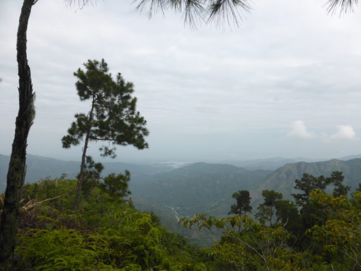
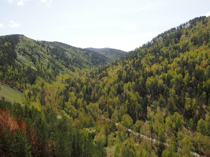
Finding ourselves firmly on the typical tourist trail, we were able to try Cubanacan who are the other state-run coach company, which transfers from a lot of the swanky central hotels in Havana and is a lot more convenient (and cheaper) than getting a taxi to the Viazul bus station. The coach trip was pleasant and uneventful, until the final descent into the Valle de Viñales and we caught our first glimpse of the unique mogote strewn landscape..

View of the Viñales countryside from the bus

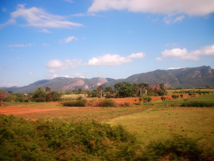
Our first glimpse of the unique Viñales landscape, lush fields strewn with limestone karsts called ‘mogotes’

From what we could make out, the little town of Viñales exists almost entirely for the service of tourists. The main street is lined with cafes and restaurants, a handful of shops, a bank, and a money exchange, while the rest of the town is comprised of casa particulars – we varied our route through the town’s back streets and it seemed like every house had a room for rent!

View of the church and town square in Viñales

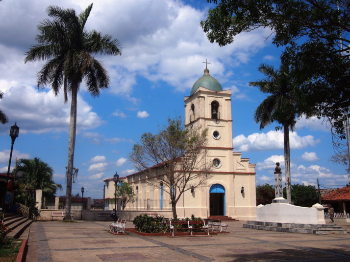
The pretty little church in Viñales

Once we’d settled ourselves into our casa and had a spot of lunch, we picked a direction and went exploring. The main street isn’t very long and we soon found ourselves down a dirt track between the deep red fields dotted with tobacco drying sheds.

A typical trail through the countryside of Viñales - deep red earth and pointed roofs of tobacco leaf drying sheds

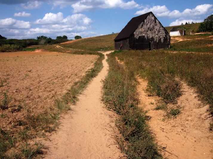
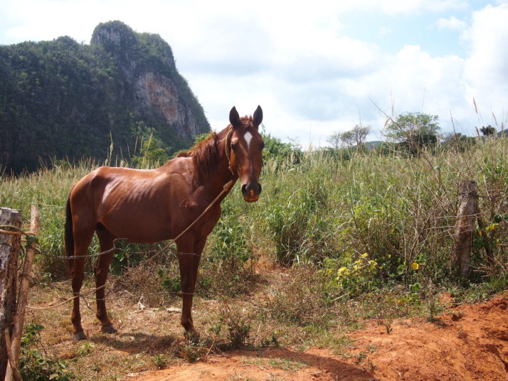
We could see from the hoof prints that we’d found one of the popular horse trails. These steep-roofed huts are tobacco drying sheds, the leaves are hung inside like kippers!

Horseback riding is a very popular activity in Viñales, and while we can see the appeal of letting the horse do the work so you can appreciate the scenery, we favoured the cycling option and arranged to hire a couple of bikes through our casa.

Julie and I with mountain bikes in Viñales

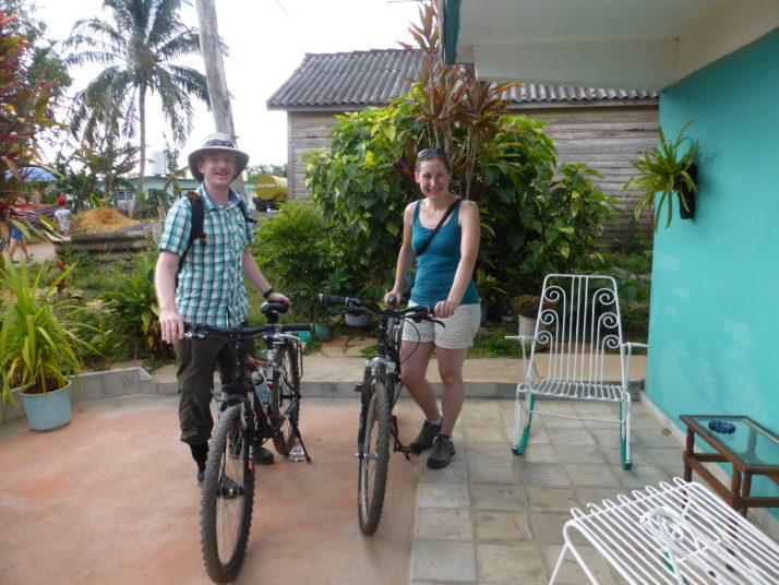
Just about to set off with a vague plan in our heads. Delightfully, my rental mountain bike was a ‘Flying Pigeon’!

No sooner had we set off than I attempted to change gears and the chain snapped! While a friendly gentleman helped me look for the missing link in the road, Julie made her way back to our casa to get in touch with the lad who’d rented us the bikes, who just happened to ride past, came over and simply swapped the disabled ‘Flying Pigeon’ for a double suspension ‘Mongoose’. I thanked them both, met up with Julie and we set off again..

Viñales national park entrance, a road heads off into the distance between two large limestone karsts

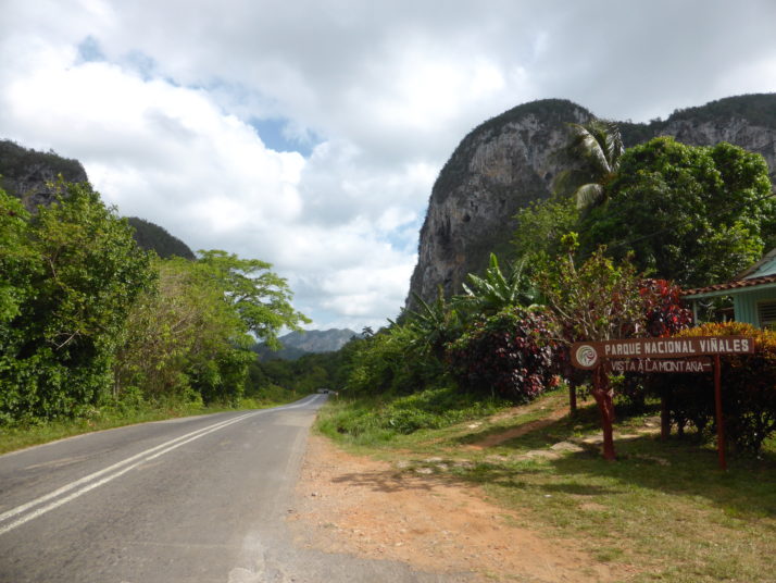
Just north of the town is the striking official entrance to the Parque Nacional Viñales

Not having intended to visit Viñales, we hadn’t done a lot of research about the area and the bike rental was simply that – here’s a bike, see you later! – no maps, hints, or suggestions! We used a combination of the Lonely Planet and the offline maps of Cuba on my phone to plan out a rough loop that took us past the Cueva del Indio, through a town called the Republica del Chile and the recommended Valle el Silencio.

Viñales countryside

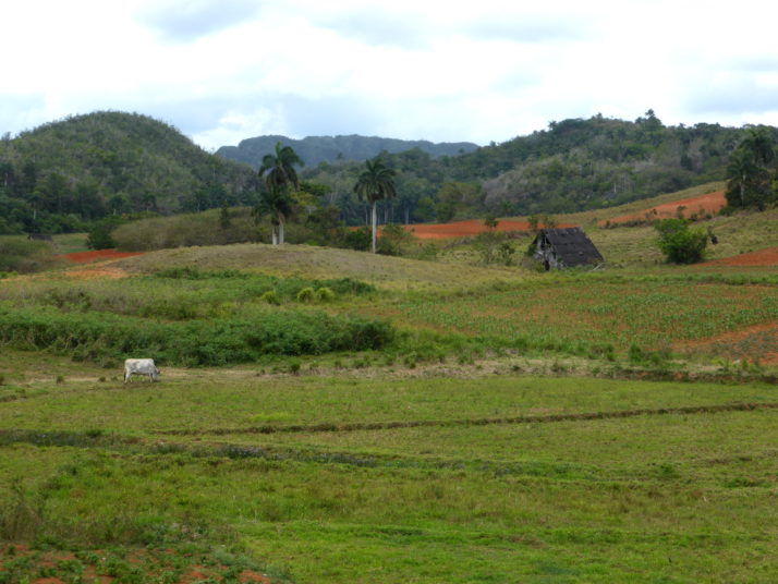
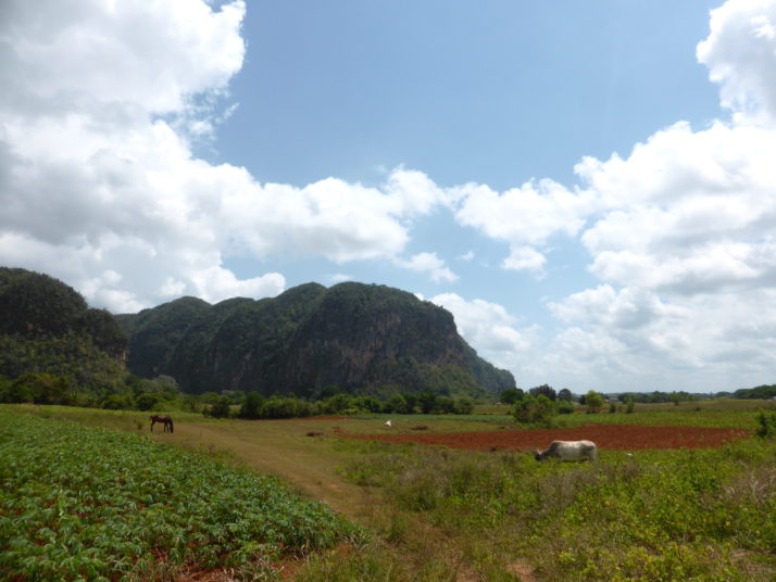
The lush valleys of Viñales – as well as tobacco, the Cubans grow coffee, sugarcane, oranges, bananas, pineapples and avocados here

Julie cycling in the Valle de Viñales

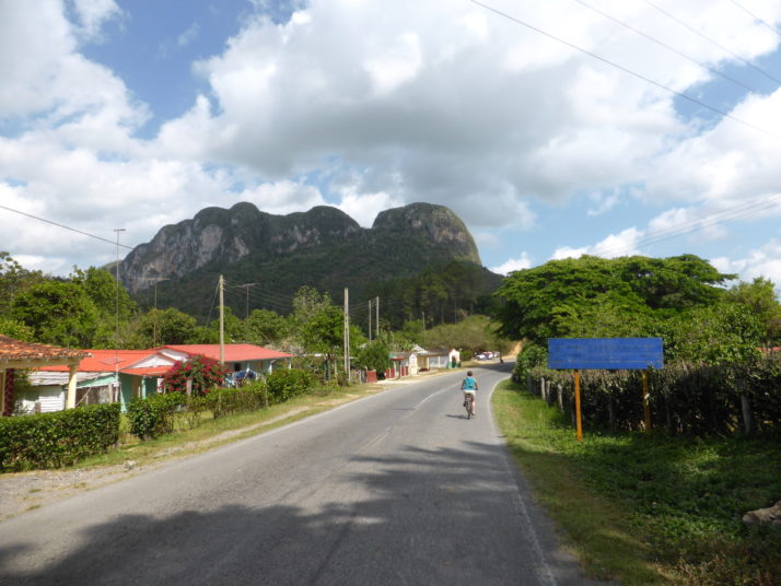
Cycling was a fantastic way to explore this amazing countryside

Viñales is a lovely place to cycle. It’s pretty flat, the scenery is varied and interesting, there are plenty of trails and when we were on the roads there wasn’t much traffic. Outside of the town there are a few places to stop for refreshments and lunch dotted here and there, though the further we travelled they were fewer and farther between. The second half of our route took us out into the wilds and it had gone 3pm by the time we found somewhere for lunch. We’d consumed all of our snacks and 4 bottles of water cycling through the heat of the day, and we hadn’t realised how ready for a break we were!

A glass of sugarcane juice in the Valle el Silencio

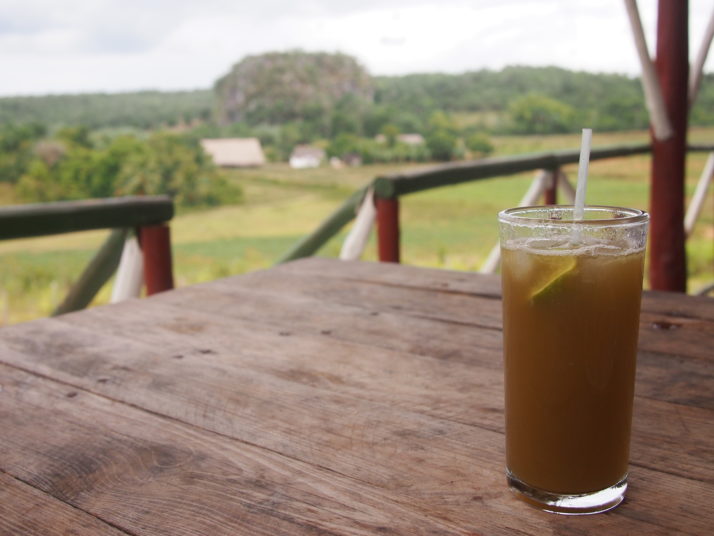
A well earned glass of sugarcane juice at our rest-stop in the Valle el Silencio

The eco-farm we found in the Valle el Silencio is very much on the independent tour guide itinerary as it’s well set up for small groups of tourists. We shared a main meal between us which was plenty, and included in the price was a tour of the adjacent organic farm which we were a little reluctant to do at first as we feared it’d be a hard sell. Our bottoms weren’t quite ready to get back onto the bikes so we relented to the tour and it turned out to be really interesting.

Collage of produce growing at tiny organic farm. Green coffee beans, a beehive and cocoa pods

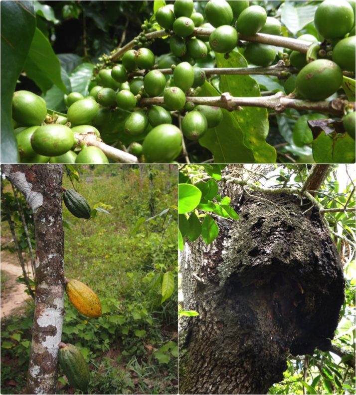
Just some of the organic produce this tiny farm grows. Clockwise from the top: coffee; a beehive for pollination of their fruit trees and honey, of course; a cocoa tree

Our young guide explained that what they grow and harvest here is primarily used in the restaurant and to feed the family. They grow a little bit of everything, I lost count of the different types of fruit but something we hadn’t seen in our travels thus far was cocoa growing on the tree.

The tour also included one of the farmers demonstrating how cigars are made in the countryside and as we’d seen them made by hand in the Partagas factory in Havana, it was fun to spot the differences in their technique and unlike in Partagas he was happy for us to take pictures..

Cigar rolling demonstration

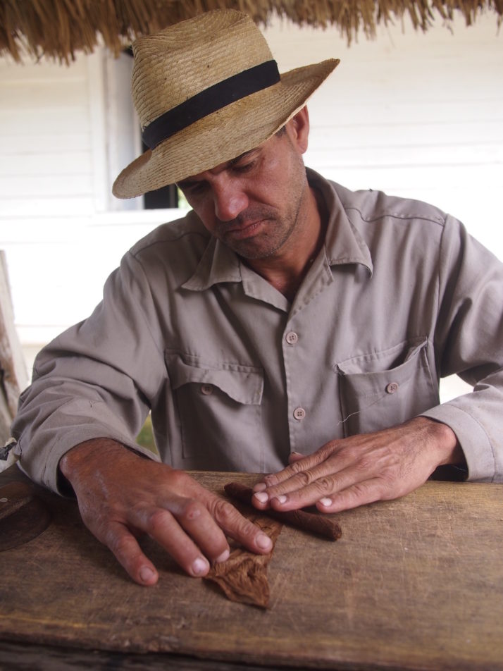
Before the final wrapper leaf is applied, the cigar would be tightly rolled in a scrap of paper for 2 days, a step that he skipped for the purposes of demonstration. And of course they’re for sale, any quantity you like for 3CUCs (£2.10) each

Apart from a short and deeply rutted part of track immediately after our late lunch stop, the remaining trail was easy going and we slowly descended through the Valle el Silencio back to Viñales. We tracked our ride on Strava and logged just over 20 miles!

For our final full day in Viñales we hiked in the other direction from our bicycle ride, notionally in the direction of a large, outdoor painting on the side of a mogote that depicts evolution and is totally panned in TripAdvisor reviews. How bad could it be? Could it be so bad that it’s actually good?

Mural de la Prehistoria, Viñales

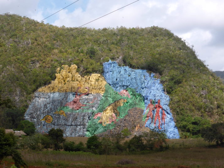
Fortunately there’s no entrance fee to stand in wonder at this almost undecipherable eyesore as it’s unmissable from the road

Moving somewhat swiftly on, the farm tracks circled round the defaced mogote and made for a fairly long but gentle walk through peaceful farmland. No noisy polluting engines, just the rustle of the gentle breeze through the fields.

Viñales countryside

Caballo, dinero, por favor

The track eventually met up with the main but not too busy road back into Viñales, and before we knew it we were back. Thank you to those that convinced us to change our plans – we’re really pleased we went – it was a peaceful, un-hassly, nature filled and relaxing change after our time in Havana.

Baracoa, Cuba

Baracoa, perched on Cuba’s eastern edge is the island’s oldest city founded in 1511 and surely also one of its smallest. It is hemmed in by mountains and rainforest, having a microclimate all its own and was isolated from the outside world until the spectacular La Farola road was opened in 1965 connecting the town with Guantanamo City and the south coast.

View from La Farola
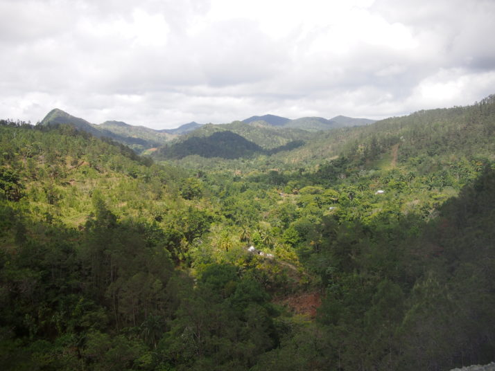
Spectacular views from the bus as we climbed through the mountains on our way to Baracoa along La Farola

El Yunque
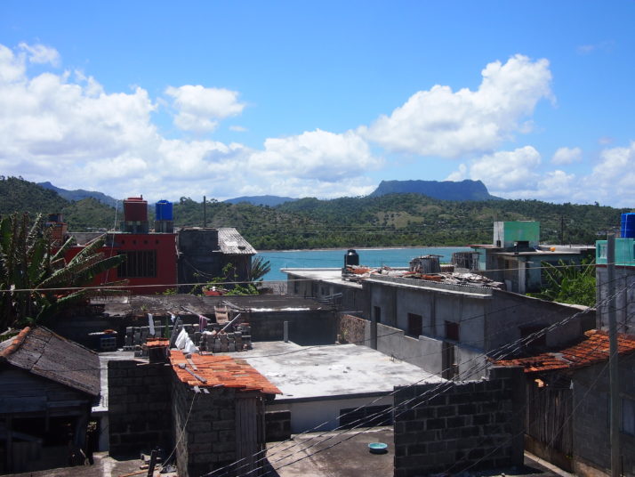
The table top mountain called El Yunque, the Anvil, is the symbol of Baracoa and is visible from many places in town including the roof terrace of our guesthouse.

Baracoa’s tiny cathedral (about the size of your average parish church) is at the centre of the town and is home to the Cruz de la Parra, the only surviving wooden cross of 29 planted in Cuba by Columbus on his first voyage and ‘discovery’ of the island in 1492.

Baracoa centre
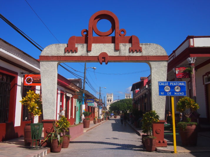
Looking along Baracoa’s walking street towards the cathedral

Cruz de la Parra
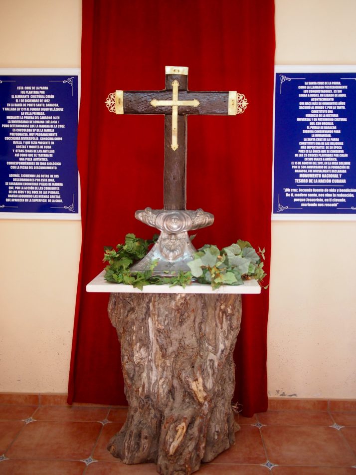
The Cruz de la Parra has been carbon dated to prove that it dates from the correct period but the wood is native Cuban and was not carried from Europe by Columbus as legend has it

The town itself doesn’t have much in the way of sights but we enjoyed strolling along the slightly dilapidated seafront to the even more dilapidated baseball stadium at the end of the beach. We also spent a fascinating hour nursing a beer on a balcony overlooking a street that was being resurfaced. It was amazing to see the hard work done by hand that we’re used to seeing machines do.

Baracoa baseball stadium
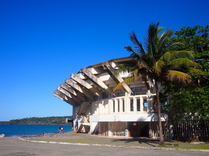
Baseball is Cuba’s national sport but its stadium was host to football practice when we poked our noses in

One morning we walked up the hill through residential streets, puzzling over why all the cockerels seemed to have no feathers on their legs or bellies until we realised they were for cockfighting.

Fighting cockerel
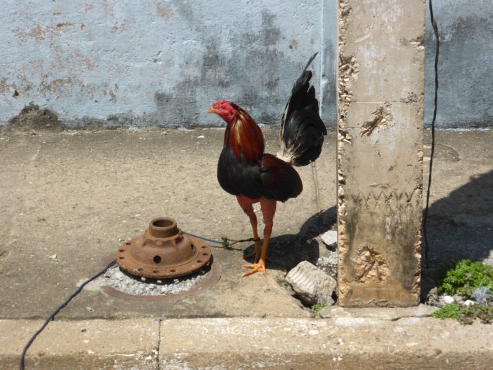
Cockfighting is a popular sport in Cuba judging by the number of cockerels we saw on a short walk through Baracoa’s streets

Dripping with sweat after the short but steep climb we arrived at the Archaeology Museum which has been imaginatively set up in a series of caves where burial chambers of the Taíno peoples had been found. The Taíno arrived in Cuba from Venezuela around 1050AD and were living there peacefully in farming communities when the Spanish arrived in the 15th century. Many died from European diseases and more when they were pressed into harsh slavery by the settlers.

Baracoa Museum of Archaeology
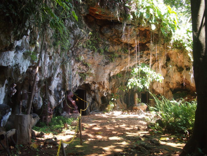
The entrance to Baracoa’s Museum of Archaeology

The displays were not so exciting but the cave setting was a quirky idea, the attendant was friendly and gave us a good explanation in English and the view over the town was superb (it’s from here that we spotted the cemetery that we visited later in our stay).

Museum of Archaeology exhibits
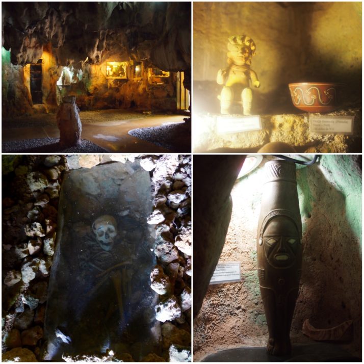
Museum of Archaeology (clockwise from top left): display cases inside the cave; Taíno artefacts; a replica of the Ídolo de Tabaco, one of the most important Taíno finds in the Caribbean; burial chamber

View over Baracoa
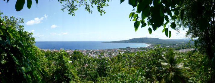
The viewpoint above the museum provides a reward for the uphill climb

We had initially planned a hiking excursion to El Yunque, but changed our minds after hearing the descriptions of the Humboldt National Park, 40km north-west of Baracoa, and went there instead. The road to the north is not in very good condition and so our group of 15 plus our guide Benny were loaded into three jeeps for the dusty hour and a half that it took to bump our way there.

Jeep transport to Humboldt National Park
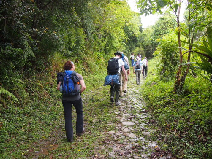
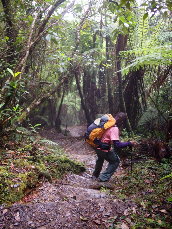
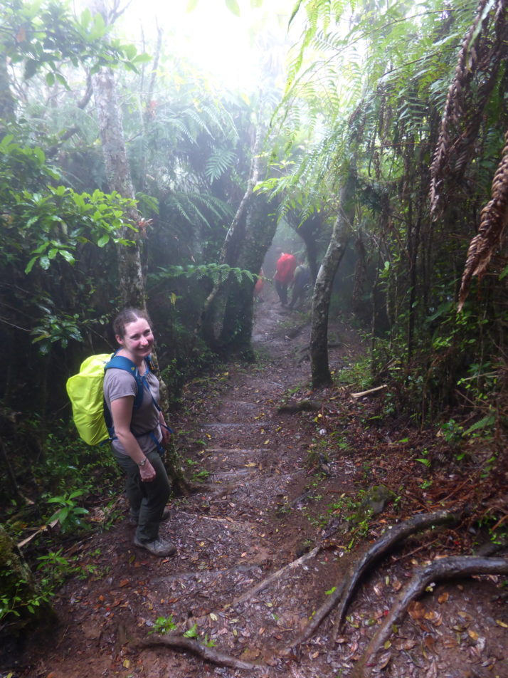
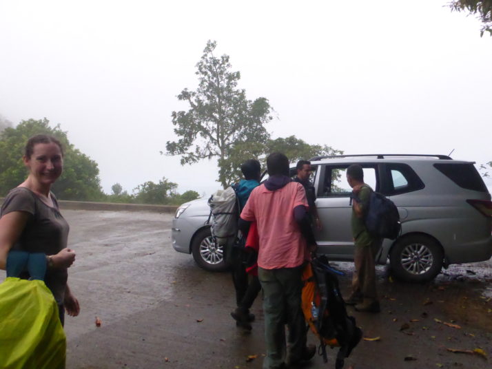
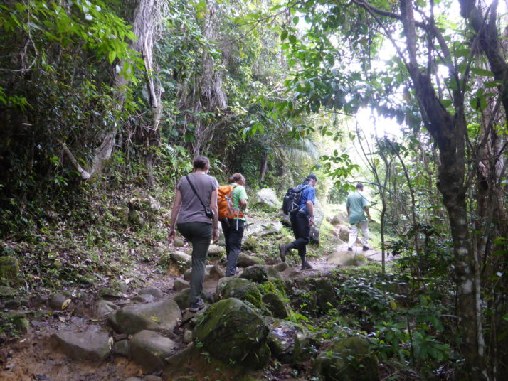
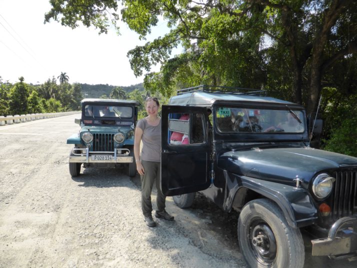
Stretching our legs during a brief pause in the drive to Humboldt National Park

The Humboldt National Park is famous for its biodiversity with lots of endemic species. 70% of the plants as well as lots of amphibians, reptiles and birds are found nowhere else, and the park was declared a UNESCO World Heritage Site in 2001.  We’d hoped that we would see quite a bit of wildlife and certainly at the beginning of the hike we did with Benny stopping to point out Tocororos, woodpeckers and parrots as well as different kinds of plants. But as the path narrowed the group became too spread out to see much and the pace felt too fast for us to fully appreciate the forest.

Flora and fauna in Humboldt National Park
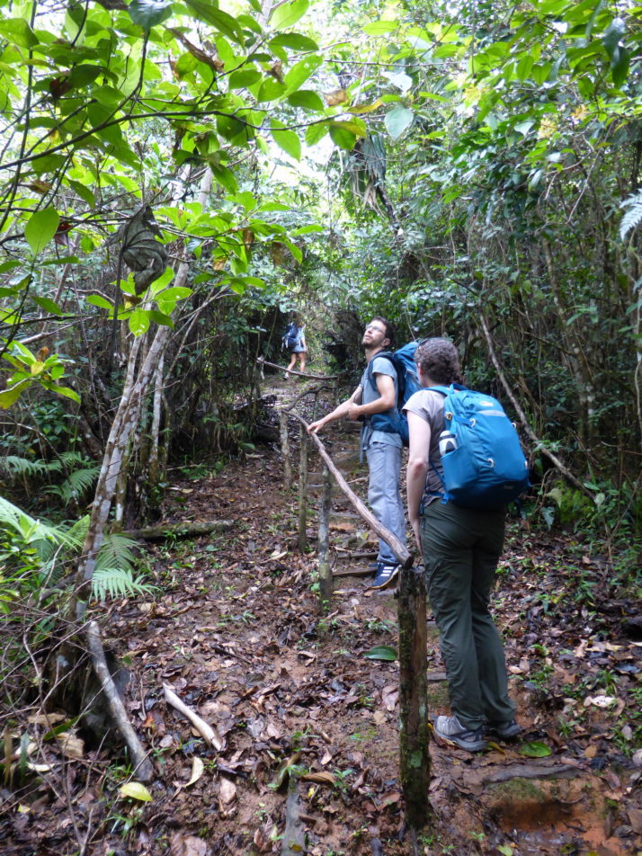
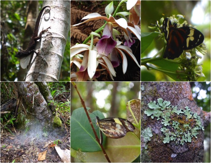
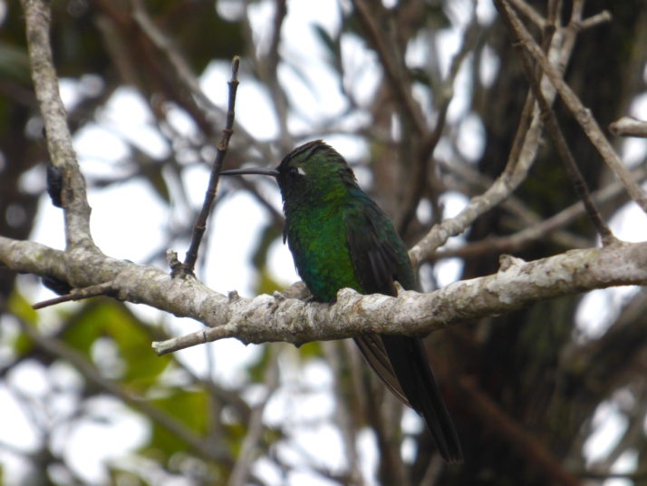
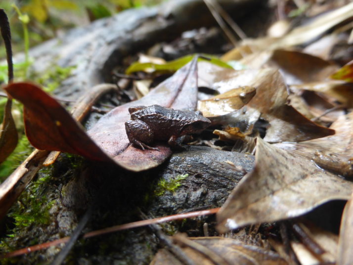
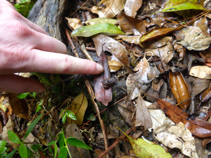
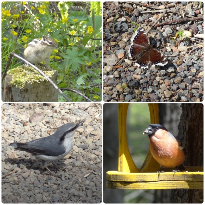
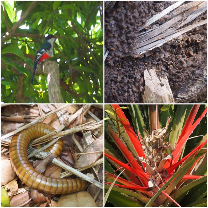
Flora and fauna in Humboldt National Park (clockwise from top left): Cuba’s national bird, the Tocororo; termites; the colourful Rat Pineapple is related to the normal pineapple but doesn’t produce an edible fruit; this huge millipede was about 25cm long and thicker than my thumb

Swimming opportunities seem to be an obligatory feature of excursions in Cuba – it felt like every time someone was trying to sell us an excursion it ended with ‘a chance to swim in the river / pool / sea’ (frankly this usually feels like a waste of excursion time to me but clearly I’m in the minority here).  Anyway this trip was no different; just before lunch we stopped at the top of a waterfall where anyone who wanted to could jump into the pool below and swim downriver to the curve where we would break for lunch. About ten of the group did, the rest of us followed the path along the river to meet them below.

Swimming in the river in Humboldt National Park
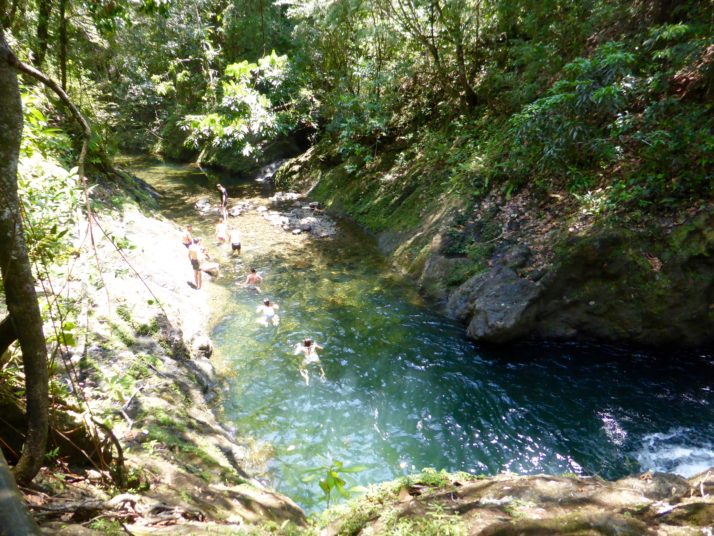
Some of our group swimming down the river to join us at the lunch spot

Crossing the river in the Humboldt National Park
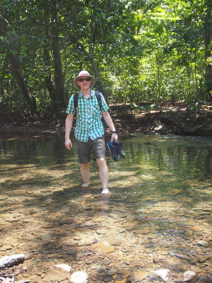
After lunch we had to cross the river 8 times to get back to where we’d left the jeeps. I was glad that I’d carried my flip-flops to cross the stony riverbed, Andrew had to do it barefoot.

On the way back to Baracoa we stopped at Playa Maguana.  It was our first Cuban beach experience and the white sand and turquoise ocean were just as breathtaking in real life as they are in the travel brochure photos.  The sea gets deep quite quickly, and the wave swells were high enough to make bobbing up and down in the water fun.  It also helped that we could take turns with the others in the group watching bags and go into the water together.

Playa Maguana
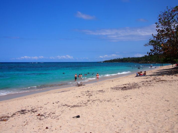
Playa Maguana, there’s even a guy who’ll bring you a drink direct to your beach towel

The Lonely Planet touts Baracoa as the best place for food in Cuba.  Now that’s not saying much as in general the island’s cuisine is not the most exciting, but still I had hoped for more than just one sauce, albeit tasty, which is served with different kinds of seafood.

Prawns in coconut milk sauce
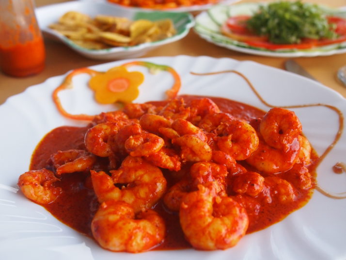
Prawns with the Baracoan sauce made from coconut milk, tomatoes, garlic and spices
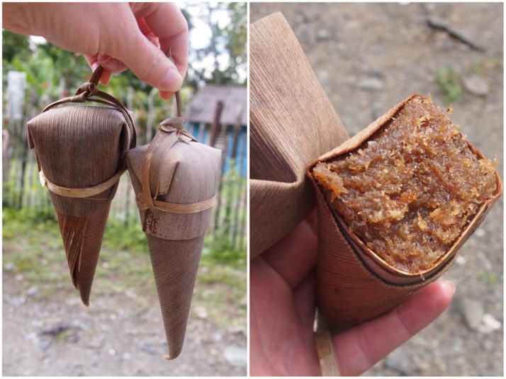
Cucuruchos are the other regional specialty, a cone of palm leaf stuffed with an almost sickly sweet mixture of fruits, coconut and honey. Baracoa is the only region in Cuba where chocolate is grown and processed (the smell wafting from the factory just outside town reminded me of driving past the Rowntrees factory in York) and we really enjoyed the huge flask of hot chocolate that was included with our breakfast each morning.

CucuruchosPeeling a cucurucho

Hiking Pico Turquino and the Comandancia de la Plata, Cuba

Day 1 – Bayamo to Camp Joaquin

Starting at 7am in Bayamo, we arrived by taxi in Santo Domingo at the foot of the Sierra Maestra mountains and the entrance to Turquino National Park at 8:30am.

There was a little waiting around until the 4WDs had ferried various groups to the starting point and then it was our turn. The low-ratio gears in the people carriers made short work of the steepest roads in Cuba (some gradients were up to 45%!), even with 9 of us, everyone’s 2-days worth of luggage, a guide and a driver onboard!

The view of the Santo Domingo valley from the Pico Turquino trail

The view of the Santo Domingo valley from the Pico Turquino trail

The starting point, 950m above sea level, is a concrete plateau or turning circle where a signpost points right for the Comandancia de la Plata, and left to Pico Turquino. From here it’s a 13 km hike where we gain just over 1,000m to reach the summit of Pico Turquino, the highest point in Cuba!

Full of energy, spirit and new faces to get know, we set off apace down the wide and easy-going track, which soon narrowed to near single-file well-maintained forested trail.

Our group starting the hike to Pico Turquino

Our group starting the hike to Pico Turquino

We’d hoped to see plenty of wildlife and we weren’t disappointed: We saw woodpeckers, Tocororos (the national bird of Cuba because its plumage is the colours of the Cuban flag: white, blue and red), a cute little green and white fluff-ball of a bird called the Cuban Tody Flycatcher, and even hummingbirds doing fly-bys right past our heads!

A Northern Flicker Woodpecker and the cute little Cuban Tody Flycatcher

A Northern Flicker Woodpecker and the cute little Cuban Tody Flycatcher

Our guide Raul was very good at stopping to point out the different flora and fauna, and at taking the time to explain a little more about them. He had a smartphone with him, and when he stopped to take a photo with it I knew it must have been for something good and close by; I took a couple of steps back to join him and saw, about 4 metres away, another Tody Flycatcher shouting at the top of his little voice!

Also in our group was a French couple and the guy was just as knowledgeable about the birds as Raul, it turned out he writes books about them!

Julie our informal guide and translator

Julie with our informal guide and translator

The forest was lush with orchids, lichen and various reptiles and insects too..

Collage of reptiles, insects and flowers

Some of the flora and insects. Clockwise from top-left: A small lizard shows off its white throat; wild orchids; we didn’t see many butterflies; but there was plenty of lichen; another rare sighting of a butterfly; blankets of spider’s webs like piled up snow at the foot of trees. We didn’t see any spiders though!

The final kilometre felt like it was really twice as long to our tired legs, and after a particularly muddy section of the trail we emerged at Camp Joaquin just after 3pm, the welcome sign greeted us with an altitude of 1364m though we’d certainly climbed more than the 414m difference since the start given the up and down terrain. After picking our bunks in the shared bunkhouse I decided to take a very cold bucket shower before we sat down for lunch.

Camp Joaquin (camp Joaquin)

Arriving at Camp Joaquin. The bunkhouse is the building on the left

Our group sharing out the well deserved lunch

Our group sharing out the well deserved lunch

Bowl of plain rice, bean soup and chayote - a vegetable that tastes like a cucumber

Mmmm.. a hot meal of plain rice, bean soup and chayote – a vegetable that tastes like cucumber

Day 2 – Camp Joaquin to Pico Turquino, then down to Santo Domingo

Alarms went off at the unsociable hour of 4:30am, and after a simple breakfast we started the final 5km ascent in the dark. I was the only person without a torch, making do with the auto-focus lamp on my camera which was enough in 2 second bursts for me to get my footing. The start was a long section of muddy stairs with the occasional handrail, and we all found it a heads down challenging start to the day.

Andrew hiking in the dark

The second day started in the dark, and involved a lot of up and down as we worked our way towards Pico Turquino

As it started getting lighter, we saw that the cloud that had come in the night before was still with us and we wondered if it would clear or be clearer by the time we made it to the top.

Julie looking from a viewpoint into a whiteout

Mirador means viewpoint in Spanish. Not much of a view past the trees this time!

Raul kept our spirits up with startlingly accurate descriptions of the trail ahead and how long it’d take to reach the next km marker or resting spot. Just before 9am we turned a corner and entered a small, foggy clearing – we’d all made it!

A very cloudy top of Pico Turquino

Made it! The top of Pico Turquino, if you can see it!

Us with Jose Marti at the top of Pico Turquino

Us with José Martí at the top of Pico Turquino

Everyone shared out the various snacks they’d brought, and we took it in turns to have our photo taken with the giant José Martí that had been hauled up some 63 years prior, before bidding him farewell and starting the 5km descent back to the camp.

As I may have mentioned previously, I much prefer hiking up to hiking down, and I don’t think I was the only one who was starting to feel tired legs and sore knees, but the scenery was new because it was now light enough to see it!

Moremi, Julie and I taking it easy on the descent

Moremi, Julie and I taking it easy on the descent

Bright green hummingbird

A hummingbird stopped on a branch next to me to say hello!

Stopping for lunch at the camp was very well received, mostly for the chance to sit down for an hour to rest our legs! Refuelled and re-packed, the only way was to continue the trail down the remaining 8km – it didn’t sound that far considering we’d already done 10km before lunch!

Julie descending in the rain

More downhill – Julie descending with a smile on her face despite the rain

Tiny frog

We’d heard about these tiny little frogs and then heard them the previous night – a chorus of clicking that sounds like a thousand pens being tapped on a wooden desk

Tiny frog with finger for scale

No wonder we couldn’t see them at night, they’re black and tiny!

With about a kilometre or so before the end the misty fog turned to rain. Everyone bar Julie and I donned their waterproofs – we’d left ours behind as we’d tried to pack light, figuring that we’d just get wet – and we got very wet indeed! So wet that we thought the 4WD wouldn’t take us back but they weren’t the least bit concerned!

Getting into the jeep at the end of day 2

Look at the relief! The final stretch of hiking in the rain wasn’t the most pleasant bit – we can’t wait to get into the jeep for a soft-seated sit down having hiked 18km!

Pico Turquino is a beautiful and challenging hike. We saw some colourful wildlife and met some adventurous people though we were all a little disappointed that the weather wasn’t better on the second day.

Day 3 – Comandancia de la Plata

We awoke from our deep restorative slumber to the sound of cockerels. Our legs felt like they’d pretty-much recovered though the soles of our feet were still a little sore and our shoes hadn’t completely dried out from yesterday’s drenching.

Our lovely hostess at Casa Arcadia made sure we were suitably fortified for another day of hiking with a typically huge Cuban breakfast and we made our way to the now familiar park entrance for the much more civilised start time of 8:30am. There was a shorter wait for the 4WD this time and a much smaller group too – just two others; an older couple from Germany and our guide Rogelio who we’d met on the hike down yesterday afternoon.

The start of the Comandancia de la Plata. 3km? After Pico Turquino that should be a doddle!

The start of the Comandancia de la Plata. 3km? After Pico Turquino that should be a doddle!

It’s a much easier hike than Pico Turquino, though the first few downhill steps were enough to remind our legs of yesterday’s soreness! We didn’t spot as much wildlife, and the route soon took us through an old farm. Today, the people who live here maintain the historic site rather than farm the land, but when Fidel and his Los Barbudos (‘the bearded ones’) regrouped and set up camp here, their support in food and silence was vital to the Revolution’s success. In return, the farmers received education and medical treatment.

Farm buildings

An old farm en-route to the Comandancia, now a base for maintenance workers

Just past the farm and up a short but steep section of trail we arrived at one of the checkpoints that encircle the Comandancia. These simple straw huts were used to control access to the camp. Of the few visitors, most weren’t allowed past them, their messages and supplies were relayed to keep the size and location of the actual campsite a secret. It worked too, Batista’s troops and reconnaissance aeroplanes never found it.

Straw hut checkpoint

Checkpoint #1 – this is as close to the camp as most people would get. Messages and supplies would be relayed from here

Just past the checkpoint, the forest and the sky opened up, welcoming us..

Arriving at the Comandancia

Just up the hill from the checkpoint. Incidentally, the hole in the foreground used to be a tree! It was taken down so Fidel’s helicopter could land when he visited on the 50th anniversary of the Revolution

The camp itself is pretty big, at its height it supported 300 troops and is spread out along both sides of the valley. The first building we came to was originally a meeting hall and hospital and is now a sort of visitor’s centre with maps, photos, copies of communications from Fidel and memorabilia such as a sewing machine and medical supplies. Julie did a fantastic job of translating the description of the camp as the centre’s attendant pointed out each building’s purpose in a model of the valley.

Inside the former meeting hall and hospital

The former meeting hall and hospital is now a visitor’s centre and museum

Rogelio then took us deeper into the camp, further than any visitors would have gone as it was explained that if they were allowed through the checkpoint then they’d be met at the meeting hall, where they only had sight of one or two other buildings and so couldn’t gauge the camp’s size. A little further into the camp we passed a signpost that read ‘Radio Rebelde’ (Rebel Radio) which pointed to a nearby peak where the rebels would raise an antennae and broadcast propaganda for a few hours every night.

Path to Radio Rebelde

The path to the peak where the Rebel Radio was broadcast

The next buildings on the trail were the storehouse, ‘cocina’ or kitchen come dining hall, and then down a narrow path and round the back of a small hill we arrived at the highlight of the Comandancia – the very well hidden Casa Fidel.

Casa Fidel, Fidel Castro's house in the mountains

Fidel’s 3-room forest abode. Dropping in unannounced, there was always the risk he wouldn’t be in

Collage of the inside of Casa Fidel

Inside Casa Fidel: the main or entrance room has a kerosene powered fridge which was used for medicines; the bedroom which doubles as an office with a writing desk

We’d read that there were 7 different exits or escape routes from Fidel’s house and it was fun walking round it to try and find them all.

Casa Fidel's outside loo

Fidel even had his own private outside toilet

Just past Casa Fidel was a 2-storey building used as a library and documents storage which was being re-constructed to the same design, simply because being made of wood it had deteriorated after 55 years.

2 storey archive building

The 2 storey archive building was being restored

We continued around the small hill and came out back at the kitchen. From there our guide was quite keen to get us back to the starting point as soon as possible as he suspected it might rain again. We passed a couple of groups heading to the Comandancia on our way back along the trail, and no sooner had we jumped into the 4WD than it did indeed start chucking it down!

Hiking back from the Comandancia

Hiking back from the Comandancia at a pace to avoid the impending rain showers

We really enjoyed the entire Comandancia de la Plata. It’s a very different experience to the Pico Turquino hike as it’s nowhere near as physically challenging even though they’re in the same region and start from the same place. Although we only got to see inside 6 of the many buildings that make up the camp, the significance is not the buildings themselves, but that the Cuban Revolution was planned and orchestrated from these simple wooden huts.

Stolby Nature Reserve, Krasnoyarsk

After our first failure at public transport in Krasnoyarsk, trying to get to the hydroelectric dam at Divnogorsk, we tried again the next day with a trip to Stolby Nature Reserve. We did all of our research the night before, cross referencing our guidebook, the nature reserve’s website (through google translate), and a website which plotted trips on Krasnoyarsk’s public transport. All of these told us that we needed to take either bus 19, 50, or 78, from the bus stop outside the Opera and Ballet Theatre. We made our way there by 10.30 and waited for 45 minutes with no sign of any of the bus numbers that we wanted… It was a very busy stop with buses arriving every couple of minutes but unlike most of the other bus stops in the city it didn’t have a sign listing the bus numbers which stopped there so it felt like there was nothing else that we could check.

We knew that the bus needed to cross the Communal Bridge to the other side of the River Yenisey to get to the nature reserve. The Opera and Ballet Theatre stop was just before the bridge so we’d seen all of the buses which crossed the river from there – what had we done wrong? At this point, I was almost ready to give up, but Andrew persuaded me that we should walk across the 2km long bridge and see if we could spot a bus going in the right direction from there. At the other end was a large roundabout, we crossed a couple of side streets and made our way to the main road which had a bus stop very close to the roundabout. Almost as soon as we got there a #19 bus arrived – hurrah at last! We got on, paid for our tickets and checked with the conductor that the bus went to Stolby receiving a nod in response.

20130610-082516.jpgOn the bus at last

After about half an hour on the bus, we checked again with the conductor, yes, she told us, four more stops. As we got off, she indicated to cross the road and told us 7km to the nature reserve. Great, that tallied exactly with the information about the reserve that we’d read. As we walked up the road opposite the bus stop, we were a bit surprised to see no signs pointing the way, but this is Russia and things are not always as clearly signposted as we’d like… After about 10 minutes of walking the road forked, again with no sign as to which way to go. After some debate, we took the rightmost, clearer track which passed behind some houses. Again, after a short walk, the clear track turned to the right with a footpath leading to the left. We knew that we needed to be heading uphill which meant taking the footpath. Hmm, it didn’t feel quite right that there wasn’t road access to the entrance of the reserve… We headed up the footpath anyway and after a short walk came to a clearing in the trees with a stunning view up the valley. Down below we could see a road leading through the trees heading in the direction we wanted – that’ll be the road we should be on then!

20130610-082549.jpgGreat view up the valley with the path that we need down below

We headed back down to the main road and a short distance along found the access road with ‘Stolby Nature Reserve’ sign at the entrance. By this point we’d wasted another hour, and with a 7km walk ahead of us before reaching the park we knew that we wouldn’t have long there before we had to come back. But it’s OK, the story has a happy ending and the day quickly began to improve. Within a few minutes walk up the path we started to see wildlife – a woodpecker, Siberian chipmunks (very cute!), butterflies, lots of different birds on a path side feeding table and even a small bat!

20130610-083247.jpgWildlife at Stolby Nature Reserve (clockwise from top left): Siberian chipmunk, butterfly, bullfinch on feeding table, Siberian nuthatch

20130610-083256.jpgA small bat flying overhead in the bright sunshine

Stolby is the Russian word for ‘pillar’ and the nature reserve takes its name from the giant boulder formations which litter the hill. They are similar to the ‘Kamennie Palatki’ in Yekaterinburg, and also reminiscent of Brimham Rocks in North Yorkshire. The path to the nature reserve is described in our guidebook as ‘a gentle uphill walk’ and it does start that way, but the last couple of kilometres are pretty steep. That, coupled with a long flight of stairs up to the first pillar, meant we could definitely feel our calf muscles the next day! Locally, the pillars are popular with rock climbers, and many of Russia’s best rock climbers have come from Krasnoyarsk region having grown up with the Stolby. We tried a bit of rock scrambling ourselves and were rewarded with an incredible view.

20130610-084624.jpgAmazing view from the ‘Ded’, or ‘Grandfather’, rock

20130610-085051.jpgRock formations and a friendly squirrel

On the way back down to the road, we had another treat in store. We were approaching one of the feeding tables and saw what we thought was another squirrel munching through the sunflower seeds, but as we got closer we saw that it was a sable! Once highly prized for their fur, these animals are usually very shy.

20130610-085349.jpg

After a frustrating start, the day turned out really well.